Land cover characterization for environmental monitoring
of pan-Europe
Vegetation Parameters Maps over Europe Using
NOAA/AVHRR in Meteorological Models
C.A. Mücher, DLO - Winand Staring Centre for Integrated Land,
Soil and Water Research (SC-DLO), Wageningen, NL
K. Steinnocher, Austrian Research Centre Seibersdorf (ARCS), Seibersdorf,
Austria
J.L. Champeaux, Meteo-France/CNRM, Toulouse, France
S. Griguolo, Instituto Universitario di Architettura (IUAV), Venice,
Italy
K. Wester, Swedish Space Corporation (SSC), Solna, Sweden
P. Loudjani, Space Applications Institute, Joint Research Centre
(SAI/JRC), Ispra, Italy
ABSTRACT: For environmental studies up-to-date and reliable
information on land use and land cover is needed. Such databases characterized
by a high spatial accuracy and that can be updated easily are currently
not available for Europe as a whole. We investigated the applicability
of satellite data for Pan-European Land Cover Monitoring (PELCOM). The
main objective was a methodology to obtain a 1-km spatial resolution pan-European
land cover database that can be updated easily using NOAA-AVHRR satellite
data. The database will be used as input for environmental impact studies
and climate research. The study takes full advantage of both multi-spectral
and multi-temporal 1-km AVHRR data. The proposed methodology for land cover
mapping has its limitations in monitoring changes due to the spatial resolution
and the limited accuracy of AVHRR derived land cover data.
1 INTRODUCTION
During the last century, land cover has been changing at an increasing rate in space and time, causing increasing pressure on the land and large impacts on our environment. Within the European context, these changes are triggered, e.g. by the Common Agricultural Policy (CAP) of the European Union and the recent upsurge of land privatization in the Eastern European countries. Both have induced processes of marginalisation and intensification, which are nowadays seen as threats to the landscapes of Europe and their biodiversity (Jongman 1996). Therefore, there is an increasing need for up-to-date and reliable information on land use and land cover (LULC) for decision support and environmental studies. Any sound environmental policy relies greatly on the outcome of environmental models, which themselves are significantly influenced by the areal and spatial accuracy of LULC data.
The ten-minute pan-European land use database (ELU-1) of the Dutch National Institute for Public Health and the Environment (RIVM) was a first step towards meeting the demands of environmental models on a European scale. The database combined non-spatial statistical information with spatial information from available land cover maps using a specific calibration procedure (Van de Velde et al. 1994, Veldkamp et al. 1995). A major drawback of the database is that the statistical and spatial data are derived from many sources that differ in spatial accuracy, reliability, acquisition date and class definitions. Moreover, the database has a low spatial accuracy, due to its dependence on statistical data. Application of remotely sensed imagery eliminates this problem, as it allows collecting up-to-date land cover data with a high spatial accuracy in a consistent way.
Current activities in the derivation of land cover databases from remotely sensed imagery that cover Europe entirely or partly comprise, amongst others, the CORINE land cover project (CEC 1993), the FIRS (Forest Information from Remote Sensing) project (Kennedy et al. 1994) and the development of a 1-km global land cover product, called DISCover (Belward 1996)
The CORINE land cover project is now implemented under supervision of the European Environment Agency (EEA). The methodology of the CORINE land cover project consists of visual interpretation of high-resolution satellite images, e.g. Landsat (TM) and SPOT (HRV XS), on a scale of 1 : 100 000, with the simultaneous consultation of additional data (CEC 1993). The legend distinguishes 44 classes grouped in a hierarchical nomenclature and is landscape and ecology oriented. For the time being, this database comprises the most consistent and detailed land cover maps available for a large part of Europe. However, the database has some limitations. First of all, the project started in 1986 and is still under development, leading to large differences in acquisition dates. Second, most CORINE classes are by nature heterogeneous, and/or are determined by its functional land use and thus consist of various land cover types. Moreover, when the database will be completed for Europe, including the Russian part of Europe, no regular updates seem feasible.
The Forest Information from Remote Sensing (FIRS) programme has been initiated by the Environmental Mapping and Modelling (EMAP) unit of the Joint Research Centre. The FIRS project aims to promote the development of methods for providing both statistical and environmental information on the forests for the whole of Europe. Remotely sensed data will be used as the major source of information. One of the project's foundation actions is the stratification, regionalization and mapping of European forest ecosystems (Kennedy et al. 1994, Kennedy et al. 1996)
Because of the lack of appropriate land cover data at a global scale, IGBP-DIS (International Geosphere and Biosphere Programmes Data and Information System) began a project in 1992 to produce a global data set at a spatial resolution of 1-km, derived from the Advanced Very High Resolution Radiometer (AVHRR) sensor onboard of the US National Oceanic and Atmospheric Administrations (NOAA) polar-orbiting satellite series. The methodology is based on clustering of monthly NDVI maximum value composites (MVC's) on a continental basis (Belward 1996). The clusters, as output of the unsupervised classification, are labeled by expert knowledge. A major limitation of the approach is that it is implemented on a continental basis without any stratification. Therefore, the result seems more closely related to agro-ecological zonation, i.e. identification of zones of similar phenology, than to the different land cover types existing in each agro-climatic zone.
The European landscape is particularly heterogeneous and fragmented and requires a stratified approach. Moreover, experiences indicate that the clustering technique does not identify forests satisfactorily. For example, for an area of 1.6 M km2 over western and central Europe the Corine land cover database aggregated to a 1-km spatial resolution identifies 26.4% of forest, while the DISCover dataset identifies 7.8% of forest. An additional limitation is that the 1-km database according to the DISCover legend contains complex classes, e.g. cropland/natural vegetation mosaics (about 27% of the pan-European land surface), which are difficult to apply in environmental studies. However, it must be stressed that the project is unique and enormous effort had to be invested in order to establish an up-to-date global land cover database at a 1-km resolution in a consistent manner. The database will play an important role in global studies, nevertheless, application of the database in environmental and climate studies for pan-Europe is rather limited.
In the current policy frameworks, such as the European Environmental
Outlook and the Economic Assessment of Priorities for a European Environmental
Policy Plan, there is a urgent need for up-to-date and reliable information
on land use and land cover that covers the whole of Europe. Such an area
covers Europe from Iceland to the Ural Mountains in West-East direction
and from Scandinavia to the Mediterranean Sea in North-South direction,
and is referred to as pan-Europe. Next to the detailed CORINE land cover
database and the global DISCover database with their own advantages and
disadvantages as mentioned above, there is a need for additional land cover
data sets for pan-Europe that fulfills the needs for environmental modeling.
Therefore a study was initiated to investigate the applicability of AVHRR
satellite data for Pan-European Land Cover Monitoring (PELCOM). Different
methodologies are assessed to map and monitor land cover of entire Europe
with low-resolution satellite data. The main objective is to arrive at
a consistent and reliable methodology for establishing and updating a 1-km
pan-European land cover database that can be used as input for environmental
impact studies and climate research.
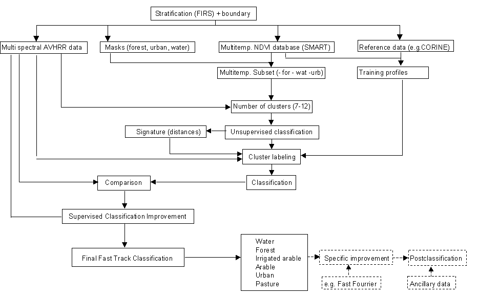
Schematic overview of proposed first track PELCOM
approach
2 FIRST RESULTS WITH AVHRR DATA
Since 1993, various pilot studies (Mücher et al. 1994, Mücher et al. 1996) have been implemented in the framework of NRSP assessing the applicability of 1-km AVHRR data for land cover mapping. In particular, improvement of the spatial accuracy of the ELU-1 was investigated.
Visual interpretation of a few AVHRR colour composites of the Netherlands, using the AVHRR channels 1, 2, 3 and/or 4, proved that main land cover classes such as grassland, arable land, forest and water could be easily identified.
The use of NDVI composites as an alternative approach was somewhat limited. Forested areas were difficult to identify and most NDVI profiles were highly disturbed by frequent cloud coverage. Besides, NDVI composites comprise only information from channel 1 and 2, ignoring the valuable information in the other AVHRR channels.
Supervised classification of several cloud-free multi-spectral AVHRR images at various stages of the growing season provided the best classification result. The classification result of each single scene was integrated in a GIS, in which the decision rules were defined explicitly, leading to the final classification result.
In addition, the 10-minute pan-European land use database (ELU-1) and the AVHRR derived classification for the Netherlands were compared with the reference database LGN-1 for accuracy assessment. The spatial accuracy of the ELU-1 was significantly lower than that of the AVHRR derived land cover database. It was concluded that applying AVHRR derived land cover data would improve the ELU-1 considerably.
At a later stage, when the AVHRR derived land cover database was extended
to France and its immediate surroundings, both databases were used as an
input in a pesticide load model designed by the Dutch National Institute
for Public Health and the Environment (RIVM), and results were compared.
An important conclusion was that load maps using the AVHRR derived land
cover database as input are to be preferred (Mücher et al.
1996). The reason was the higher spatial accuracy and the more consistent
quality and, hence, resulting in better loads estimates. Land use databases,
such as ELU-1, suffer from averaging the pesticide load. The main disadvantage
of the AVHRR derived land cover database was the absence of the class of
permanent crops, e.g. vineyards, which receive high pesticide doses.
3 TOWARDS AN OPERATIONAL METHODOLOGY
Phase one ''methodology development'' of the PELCOM project has been finalised and main results are summarised below. The rest of the year will be used for the classification experiments. The year 1999 will be used for the case studies.
Within phase one, a fast-track classification methodology has been developed that is applicable for pan-Europe (Figure 1). The PELCOM classification scheme consists of six major land cover classes: forest, grassland, arable land, urban area, barren land and water bodies. The distinction of the various forest types, grassland types and wetlands, as was foreseen, does not seem to be feasible at the moment.
Working on such a large area as the whole of Europe made stratification a prerequisite. A stratified approach improves the accuracy and detail of the classification. In the framework of the FIRS (Forest Inventory by Remote Sensing) project of SAI/JRC, a regionalization and stratification was made for European forest ecosystems (Kennedy et al. 1994, Kennedy et al. 1996). The 115 strata constituting the output of the FIRS stratification were found to be suitable for PELCOM.
The major AVHRR data source is the MARS (Monitoring Agriculture by Remote Sensing) archive at SAI/JRC. Contrary to the multi-spectral daily images from the archive, the derived Maximum Value Composites did not meet the required quality. Therefore, an improved multi-temporal data set was processed by the SMART (Smoothing AVHRR Reflectances Technique) algorithm, which has been developed also by SAI/JRC. The algorithm contains the following steps (Loudjani et al. in prep.): missing data, high scan angle rejection, scan angle effect correction, cloud screening, sharp variation rejection, weighted moving average smoothing and time interpolation. The algorithm processes directly the values from the visible and near-infrared channels and gives the end-user the opportunity to choose his own defined vegetation index.
The SMART database, as produced at SAI/JRC, forms the core of the classification procedure. Clustering techniques will be applied to the SMART database containing smoothed profiles for VIS and NIR channels on a daily basis. Unfortunately, forests are not satisfactorily identified in a clustering procedure. In a supervised classification forests can be identified on individual multi-spectral scenes using channels 1, 2 and 3 (ESA 1992, Mücher et al. 1994). However, such an approach is hampered by frequent occurrence of clouds. Therefore, identification of forests was implemented on the basis of thresholding the synthesis of visible reflectance of AVHRR channel one (Champeaux and Legleau 1995). Additional masks were produced for water bodies and urban areas. Before any classification, these masks are applied on all AVHRR data. Subsequently, an unsupervised classification is executed on the SMART data per stratum. Visual interpretation of cloud-free multi-spectral AVHRR scenes, training samples derived from the CORINE land cover database and/or statistical data from the region will help to determine the adequate number of clusters per stratum and their labelling.
Because the clusters might reflect heterogeneous areas consisting of
several land cover types, for each pixel the minimum and second minimum
distance will be calculated, i.e. each pixel will receive a first and a
second likely class number. In addition, the ratio between the first and
second distance is computed
and assigned to a third layer. The ratio between the distances can be used as a measure for the "pureness" of the single pixel. A pixel that is located close to one cluster will have a very low ratio whereas a pixel that is located in the middle between two clusters will have a ratio close to one.
The information in either the multi-temporal or multi-spectral AVHRR
data will be strongly influenced by the quality of the concerned data and
the land cover types and patterns present in the specific stratum. If specific
features, e.g linear features, and specific land cover classes are only
well visible in the multi-spectral AVHRR scenes, such as irrigated arable
land, they will be derived from these scenes by a supervised classification.
4 CONCLUSIONS AND FUTURE OUTLOOK
This paper has presented in the framework of the European Union funded PELCOM project an enhanced classification methodology to map major land cover types for the whole of Europe using NOAA-AVHRR satellite data. Both multi-temporal profiles of AVHRR channel one and two and multi-spectral AVHRR scenes are used as an input in the classification procedure. The classification scheme will be used to establish a land cover database of pan-Europe that fulfils the needs for environmental modeling. Such a database requires identification of major land cover types, such as forests, grassland, arable land and water, with a spatial resolution of about 1 x 1 km2.
A restriction of AVHRR derived land cover maps is the low overall accuracy, which in general does not exceed 70 percent. Comparing two AVHRR derived land cover maps of different dates for change detection will result in change maps of even lower accuracy. Therefore, additional techniques have to be developed for change detection, such as the use of fraction images derived from linear unmixing techniques (Kressler and Steinnocher, 1998).
Besides the demonstrated application of the AVHRR derived land cover database in the estimates of pesticide loads, such a database can play an important role, e.g., in biodiversity research related to fragmentation and potential habitat studies or biogenic emission inventories on a European scale. Unfortunately, the use of AVHRR data is limited in the identification of classes such as wetlands and forest subclasses within the European context.
It is expected that additional use of new sensors such as the VEGETATION
instrument onboard of SPOT-4, the planned MERIS sensor onboard of ENVISAT
and the MODIS sensor onboard EOS-AM and EOS-PM satellite will improve land
cover mapping and monitoring results due to better radiometric and geometric
quality.
REFERENCES
CEC, 1993, CORINE Land Cover technical guide. European Union. Directorate-GeneralEnvironment, Nuclear Safety and Civil Protection. Luxemburg: Office for Official Publications of the European Communities. (EUR, ISSN 1018-5593, ISBN 92-826-2578-8).
Champeaux, J.L. and Legleau, H., 1995, Vegetation mapping over Europe using NOAA/AVHRR. Meteorological Satellite Data Users Conference, Winchester, UK, pp 139-143.
ESA, 1992, Remote Sensing Forest Map of Europe. ESA/ESTEC, ISY Office, Noordwijk, the Netherlands, map and report, 18 pp.
Jongman, R.H.G., 1996, Ecological and Landscape consequences of land use change in Europe. Proceedings of the first ECNC seminar on land use change and its ecological consequences, 16th - 18th of February 1995, Tilburg, the Netherlands. ECNC publication series on Man and Nature, Volume 2, November 1996. ISBN 90-802482-1-5.
Kennedy, P., Folving, S. and McCormick, N., 1994, An introduction to the FIRS project. Proceedings to the International Conference on satellite Technology and GIS for Mediterranean Forest Mapping and Fire Management. Aristolian University, Thessaloniki, Greece, 4-6 November 1993. (EUR 1586 EN), pp. 294-304.
Kennedy, P., D.P. Roy, S. Folving and J. Mégier, 1996, The application of the FIRS Projects Foundation Action 1, the regionalization and stratification of European forest ecosystems, for providing a European NOAA-AVHRR-based forest map. Proceedings to the 15th EARSeL Symposium on Progress in Environmental Research and Applications Basel, Switzerland 4-6 September 1995 (Parlow ed.), pp 43-53.
Kressler F.P. and Steinnocher K.T. (1998): Detecting land cover changes from NOAA-AVHRR data using spectral mixture analysis. Proc. EARSeL Symp. Operational Remote Sensing for Sustainable Development, NSEOG workshop on "land use / land cover change: methods and applications", Enschede, The Netherlands, 11.-15. May 1998 (in press).
Loudjani, P., Pinty, B., and Verstraete, M. 1998, The SMoothing Avhrr Reflectances Technique (SMART): a method for smoothing AVHRR reflectance time-series (In prep.).
Mücher, C.A., Veldkamp, J.G., van Katwijk, V.F., Nieuwenhuis, G.J.A. and van de Velde R.J., 1996, Applicability of NOAA-AVHRR 1-km data for land cover based environmental monitoring in Europe: final report part 1. SC-DLO report 128, Wageningen ,The Netherlands. RIVM report no. 724001002.
Van de Velde, R.J., Faber, W.S., van Katwijk, V.F. , Kuylenstierna, J.C.I. , Scholten, H.J., Thewessen, T.J.M., Verspuij M. and Zevenbergen M., 1994, The preparation of a European land use data base. RIVM report no. 712401 001, Bilthoven, the Netherlands. 63p.
Veldkamp, J.G., Faber, W.S., Van Katwijk, V.F., Van de Velde, R.J., 1995, Enhancements on the European land use database. RIVM report no. 724001001, Bilthoven, the Netherlands.
VEGETATION PARAMETERS MAPS OVER EUROPE USING NOAA/AVHRRIN METEOROLOGICAL MODELS
J-L Champeaux, J. Noilhan, E. Bazile, D. Giard
METEO-FRANCE/CNRM 42, av Coriolis 31057 TOULOUSE, FRANCE
Phone: (33) . 5. 61.07.93.55; Facsimile: (33) 5.61.07.96.26
email: Jean-louis.champeaux@meteo.fr
During the last decade, different studies have proved the necessity to describe accurately the land surface processes in numerical weather prediction (NWP) models, both for large-scale and mesoscale models.
The land surface scheme (ISBA) developed at CNRM was implemented recently in ARPEGE, the french global NWP model. The ISBA scheme requires a few key parameters prescribed from a vegetation map and a soil map. Up to now, the meteorological community used the Henderson-Sellers database at the global scale with a resolution of one degree. This resolution is unsuitable for NWP models operating with a grid box of a few kilometers size. For this reason, a methodology for producing vegetation parameters maps from satellite data has been developed over Europe with a 1km resolution.
First of all, an archive has been created by Meteo-France over Europe since 1990. From April 1992 to December 1994, AVHRR channels 1 and 2 were processed at 2 km resolution over Europe; the processing includes cloud detection, navigation and atmospheric corrections. Montly NDVI maps are computed using the MVC technique. A thresholding on monthly visible reflectances is used to map forests; then, an automatic classification is performed on monthly time series of NDVI to obtain a 11 classes map: forests, grasslands, orchard and bare ground, and several classes of crops characterized by their NDVI temporal signature. The second phase consists of assigning monthly values of input parameters of ISBA (roughness length, leaf area index, fraction of vegetation, minimum stomatal resistance) to each class of vegetation using look-up tables. The variation of the NDVI profiles are used to derive the seasonal variations of LAI between a minimum and a maximum values issued from local calibration of ISBA or literature. Finally, the parameters are averaged within each grid box using agregation rules.
The impact of ISBA scheme using the new vegetation map over EUROPE has been evaluated in the ARPEGE NWP model in 1997. The new assimilation has improved significantly the forecast skills for screen temperature and relative humidity. The statistics of 20 consecutive days of assimilation with ISBA and the old scheme show clearly the improvement over Europe. The daily cycle of humidity has been partly corrected with ISBA; furthermore in Spain, the temperature bias is reduced by a factor 2. In the old scheme, the fraction of vegetation was too high resulting in a cold and wet bias at the surface; with the new vegetation map and the ISBA calibration, the surface flux treatment has been improved over Europe.
The characterization of vegetation properties with a good resolution in space (i.e the kilometer) and in time (ten days) is essential at global scale for a good implementation of surface schemes in NWP models.
PELCOM PublicationsChampeaux J-L, D. Arcos, E. Bazile, D. Giard, J. Noilhan, 1998; Vegetation parameters maps over Europe using NOAA/AVHRR in Meteorological models. In IEEE International Geoscience and Remote Sensing Symposium, Seattle 6-10 July 1998, Vol. III, pages 1726,1728.
Champeaux J-L, D. Arcos, E. Basile, J.P Goutorbe, D. Giard, F. Habets, J. Noilhan, and J.L Roujean, 1998; AVHRR-derived vegetation mapping over western Europe for use in numerical weather prediction models. Int. J. Remote Sensing. Submitted.
Katwijk , van V. and W. Boersma, 1998; Land Use Integrator. Pan-European Land CoverMonitoring (PELCOM). Presented at 18th EARSEL Symposium, Enschede, 11-13th June 1998.
Kressler F. and Steinnocher K., 1996; Change detection in urban areas using satellite data and spectral mixture analysis. International Archives of Photogrammetry and Remote Sensing, 31, B7, 379-383.
Kressler F.P., Steinnocher, K.T, 1998; Applying a linear unmixing method to determine the abundance of different land cover types from NOAA-AVHRR data 27th International Symposium on Remote Sensing of Environment, Tromsø, Norway, 8-12 June 1998, pp. 407-410 1998. Proceedings.
Kressler F.P., Steinnocher, K.T, 1998; Detecting land cover changes form NOAA-AVHRR data using spectral unmixing analysis. EARSeL Symposium on operational remote sensing for sustainable development, , Enschede, The Netherlands, 11-14 May 1998.
Mücher, C.A., Steinnocher, K., Kressler, F and C.Heunks, 1998; Land cover characterization and change detection for environmental monitoring of pan-Europe. Submitted to International Journal of Remote Sensing (special issue on Global and Regional Land Cover Characterization from Remotely Sensed Data). Submitted.
Mücher, C.A., K. Steinnocher, J.L. Champeaux, S. Griguolo, K. Wester and P.Loudjani, 1998; Land Cover Characterization for environmental monitoring of pan-Europe. In: Proc. 18th EARSEL Symp. on Operational Remote Sensing for Sustainable evelopment, ITC, Enschede, 11-13th May 1998, pp 107-113.
Veldkamp J.G., C. Heunks, V.F. van Katwijk, M. Barkhof , C.A. Mücher
and B.J.E. ten Brink, 1998; Towards an improved methodology for Pan-European
land cover classification. Applicability of NOAA-AVHRR and ancillary data
for land cover based environmental monitoring on a European scale. Final
Report part 2. BCRS publication 98-06, Delft, the Netherlands, pp.90.
Posters
C.A. Mücher & J.G. Veldkamp, 1998; An approach for Pan-European Land Cover Mapping.Presented at GCTE-LUCC Open Science Conference, 14-18 March 1998, Barcelona, Spain.
C.A. Mücher, J.G. Veldkamp, C. Heunks, P.Loudjani, V.Perdigao, K.Steinnocher, F. Kressler, V. van Katwijk, M. Barkhof, J.P. Goutorbe, J.L. Champeaux, R. Leemans, S. Griguolo, K.Wester and O. Furberg, 1998; Pan-European Land CoverMonitoring (PELCOM). Presented at 18th EARSEL Symposium, Enschede, 11-13th June 1998.